Analisis Kerentanan Banjir Menggunakan Metode Normalised Morphometric Flood Index (NMFI) Studi Khusus: SubDAS Air Manna, Bengkulu Selatan
DOI:
https://doi.org/10.56099/ophi.v6i1.p1-10Keywords:
Air Manna, banjir, DAS, morfometri, NMRAbstract
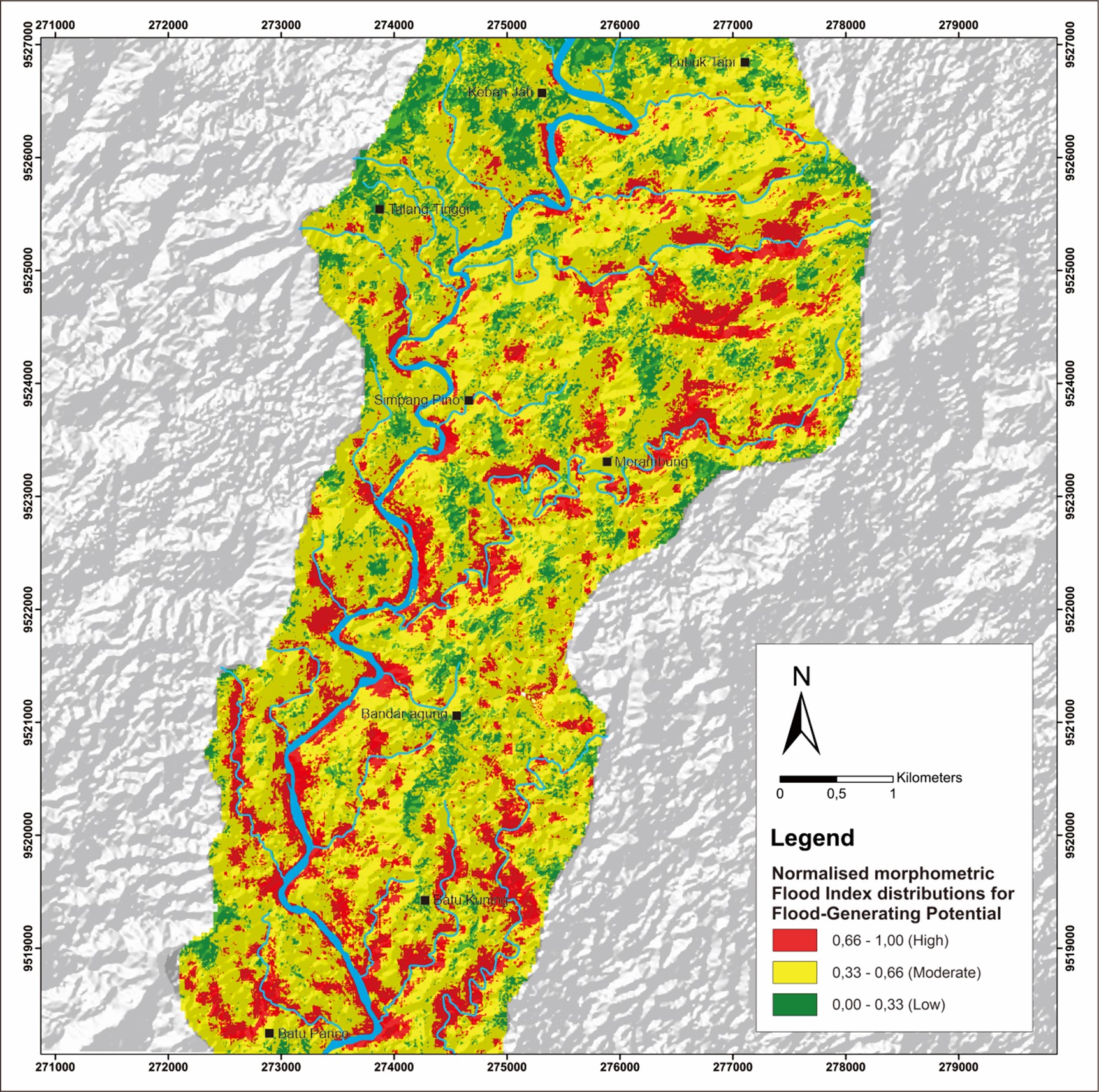
Air Manna River is the main river that accommodates water flow from small rivers in the Air Manna sub-watershed. This river has a reasonably large water discharge. One way to determine a watershed's flood disaster potential is by using the morphometric aspect approach to the watershed. After analysing the morphometric parameters, it was found that some areas in the Air Manna sub-watershed have high flood potential. These areas are areas with high drainage density values, high main channel slope in the river flow, low length of overland flow values, high ruggedness number, and low bifurcation ratio values. Furthermore, the results of the morphometric parameter analysis of the research area will be normalized using the Normalized Morphometric Flood Index (NMFI) method. NMFI simplifies the values of the morphometric parameter analysis results into the range 0 - 1, which aims to reduce the subjectivity of the analysis results so that it will increase the accuracy of the analysis data. Based on the results of processing with the NMFI method, three levels of flood hazard were obtained, i.e. low, medium, and high, which are depicted by green, yellow, and red colours on the map. Areas with low hazard levels amounted to 5.98% or 2009.75 km2, medium hazard levels amounted to 80.09% or 26916.64 km2, and areas with high hazard levels amounted to 13.92% or 4678.23 km2.
References
Amri, K., Ramadhan, M. H. & Fauzi, M. 2021. Analisis Debit Puncak Pada Das Air Manna Bagian Hilir Menggunakan Pendekatan Metode Hidrograf Satuan Sintetis (Hss) Snyder Dan Hec-Ras 5.0.7. Jurnal Teknik Sipil Cendekia (Jtsc), 2(2), pp. 35-50. https://doi.org/10.51988/jtsc.v2i2.32
Anwar, S. & Amri, M. A. 2024. Hubungan Laju Infiltrasi terhadap Permeabilitas Tanah dan Muka Airtanah di Daerah Desa Tajur Kecamatan Citeureup. Journal of Geoscience Engineering & Energy, 5(1), pp. 50-60. https://doi.org/10.25105/jogee.v5i1.18939
Ashmawy, M. H., El-Wahed, M. A. A., Kamh, S. Z. & Shebl, A. 2018. Comparative study of the drainage basin morphometry extracted from topographic maps and SRTM DEMs: an example from Ghadir watershed, Eastern Desert, Egypt. Delta Journal of Science, 39(2), pp. 52-64. https://doi.org/10.21608/djs.2018.138907
Bhat, M. S., Alam, A., Ahmad, S., Farooq, H. & Ahmad, B. 2019. Flood hazard assessment of upper Jhelum basin using morphometric parameters. Environmental Earth Sciences, 78(2), pp. 54. https://doi.org/10.1007/s12665-019-8046-1
Bloschl, G., Kiss, A., Viglione, A., Barriendos, M., Bohm, O., Brazdil, R., Coeur, D., Demaree, G., Llasat, M. C., Macdonald, N., Retso, D., Roald, L., Schmocker-Fackel, P., Amorim, I., Belinova, M., Benito, G., Bertolin, C., Camuffo, D., Cornel, D., Doktor, R., Elleder, L., Enzi, S., Garcia, J. C., Glaser, R., Hall, J., Haslinger, K., Hofstatter, M., Komma, J., Limanowka, D., Lun, D., Panin, A., Parajka, J., Petric, H., Rodrigo, F. S., Rohr, C., Schonbein, J., Schulte, L., Silva, L. P., Toonen, W. H. J., Valent, P., Waser, J. & Wetter, O. 2020. Current European flood-rich period exceptional compared with past 500 years. Nature, 583(7817), pp. 560-566. https://doi.org/10.1038/s41586-020-2478-3
BNPB. 2019. Infografis Banjir Longsor Bengkulu Tahun 2019 [Online]. Badan Nasional Penanggulangan Bencana. URL: https://bnpb.go.id/infografis/infografis-bencana-banjir-dan-longsor-bengkulu [diakses pada Juni- 2023].
BNPB. 2020. Bengkulu Kembali Alami Bencana Hidrometeorologi, Waspadai Dampaknya [Online]. Badan Nasional Penanggulangan Bencana. URL: https://bnpb.go.id/index.php/berita/ [diakses pada Januari- 2024].
Dwangga, M. & Farida, A. 2022. Potensi Banjir Bandang Menggunakan Analisis Morfometri di Daerah Aliran Sungai Klagison Kota Sorong. ECOTROPHIC : Jurnal Ilmu Lingkungan (Journal of Environmental Science), 16(1), pp. 71-80. https://doi.org/10.24843/EJES.2022.v16.i01.p07
Eryani, I. G. A. P. 2021. Aplikasi Sistem Informasi Geografis untuk Pengelolaan DAS Terpadu. Surabaya, Scopindo Media Pustaka.
Handayani, D., Soelistijadi, R. & Sunardi 2005. Pemanfaatan Analisis Spasial untuk Pengolahan Data Spasial Sistem Informasi Geografi. Jurnal Teknologi Informasi DINAMIK, 10(2), pp. 108-115.
Heryanto, R. 2007. Karakteristik batubara di Cekungan Bengkulu. Indonesian Journal on Geoscience, 2(4), pp. 247-259. https://doi.org/10.17014/ijog.vol2no4.20075
Horton, R. E. 1932. Drainage‐basin characteristics. Eos, Transactions American Geophysical Union, 13(1), pp. 350-361. https://doi.org/10.1029/TR013i001p00350
Horton, R. E. 1945. Erosional Development of Streams and Their Drainage Basins; Hydrophysical Approach to Quantitative Morphology. Geological Society of America Bulletin, 56(3). https://doi.org/10.1130/0016-7606(1945)56[275:Edosat]2.0.Co;2
Manjare, B. S., Khan, S., Jawadand, S. A. & Padhye, M. A. 2018. Watershed Prioritization of Wardha River Basin, Maharashtra, India Using Morphometric Parameters: A Remote Sensing and GIS-Based Approach. In: Singh, V. P., Yadav, S. & Yadava, R. N., eds. Hydrologic Modeling, Singapore. Springer Singapore. pp. 353-366.
Munoz, S. E., Giosan, L., Therrell, M. D., Remo, J. W. F., Shen, Z., Sullivan, R. M., Wiman, C., O'Donnell, M. & Donnelly, J. P. 2018. Climatic control of Mississippi River flood hazard amplified by river engineering. Nature, 556(7699), pp. 95-98. https://doi.org/10.1038/nature26145
Nugraha, H. & Cahyadi, A. 2012. Analisis morfometri menggunakan sistem informasi geografis untuk penentuan SubDas prioritas (Studi kasus mitigasi bencana banjir bandang di Das Garang Jawa Tengah). Seminar Nasional Informatika Yogyakarta. UPN Veteran Yogyakarta. pp. E22-E28.
Ozdemir, H. & Akbas, A. 2023. Is there a consistency in basin morphometry and hydrodynamic modelling results in terms of the flood generation potential of basins? A case study from the Ulus River Basin (Türkiye). Journal of Hydrology, 625, pp. 129926. https://doi.org/10.1016/j.jhydrol.2023.129926
Prabowo, A. 2022. Identifikasi Morfometri DAS Serang dari Citra SRTM. Kurvatek, 7(1), pp. 25-30. https://doi.org/10.33579/krvtk.v7i1.2762
Prahasta, E. 2002. Sistem Informasi Geografis: Konsep-Konsep Dasar Informasi Geografis. Informatika Bandung.
Rochman, H. N., Andawayanti, U. & Fidari, J. S. 2022. Aplikasi Sistem Informasi Geografis Untuk Evaluasi Sistem Jaringan Drainase Di Sub DAS Kota Malang. Jurnal Teknologi dan Rekayasa Sumber Daya Air, 2(2), pp. 117-127. https://doi.org/10.21776/ub.jtresda.2022.002.02.10
Schumm, S. A. 1956. Evolution of Drainage Systems and Slopes in Badlands at Perth Amboy, New Jersey. Geological Society of America Bulletin, 67(5), pp. 597-646. https://doi.org/10.1130/0016-7606(1956)67[597:Eodsas]2.0.Co;2
Strahler, A. N. 1964. Quantitative geomorphology of drainage basin and channel networks. In: Chow, V. T. (ed.) Handbook of applied hydrology. McGraw-Hill. pp. 39-76.
Sutisna, A. S. & Putro, H. 2019. Evaluasi Tingkat Akurasi Digital Elevation Model (DEM) SRTM dan ASTER GDEM dalam Pemodelan Daerah Aliran Sungai (DAS) Ciliwung. Media Komunikasi Teknik Sipil, 24(2), pp. 105-112. https://doi.org/10.14710/mkts.v24i2.17541
Tanoue, M., Taguchi, R., Alifu, H. & Hirabayashi, Y. 2021. Residual flood damage under intensive adaptation. Nature Climate Change, 11(10), pp. 823-826. https://doi.org/10.1038/s41558-021-01158-8
Wibowo, K. M., Kanedi, I. & Jumadi, J. 2015. Sistem Informasi Geografis (SIG) Menentukan Lokasi Pertambangan Batubara di Provinsi Bengkulu Berbasis Website. Jurnal Media Infotama, 11(1), pp. 51-60. https://doi.org/10.37676/jmi.v11i1.252
Downloads
Published
How to Cite
Issue
Section
License
Copyright (c) 2024 Muhammad Izzul Islam, Budhi Setiawan

This work is licensed under a Creative Commons Attribution-ShareAlike 4.0 International License.