Pengaruh Perubahan Tutupan Lahan terhadap Pola Banjir di Ibu Kota Provinsi Lampung: Studi Menggunakan SIG dan Pendekatan Temporal
DOI:
https://doi.org/10.56099/ophi.v6i1.p29-35Keywords:
banjir, bandar lampung, SIG, temporal, tutupan lahanAbstract
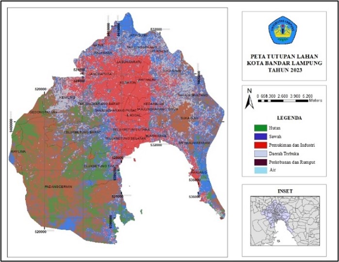
Bandar Lampung often faces major challenges related to flooding. In recent years, flooding in the city has become a serious problem that requires special attention and handling. Infrastructure development and continuous population growth affect changes in the city's environmental setting. From the continuous flooding in Bandar Lampung city, it is necessary to analyse flood patterns with a spatial and temporal approach. The utilization of Geographic Information System (GIS) method is one of the effective ways in making maps with various data used such as rainfall, land cover, watershed, slope, and information on flood incidents over a 10-year period, from 2013 to 2023. The watershed, land cover and slope data also provide an overview of the dynamics of water flow and its influence on flood-prone areas. From the data, it was found that the distribution of Bandar Lampung urban forest area decreased by 63859.61 ha from 83778.11 ha to 19918.5 ha or about 23.8% of the Bandar Lampung City area. In addition, there was an increase in residential and industrial areas of 36750.95 ha from 2013 of 27143.83 ha to around 63,894.78 ha or approximately 76.2% of the total area of Bandar Lampung City. This research contributes to the importance of understanding the dynamics of flooding in Bandar Lampung City and contributes to the understanding of the dynamics of flooding in Bandar Lampung City.
References
Ariyora, Y. K. S., Budisusanto, Y. & Prasasti, I. 2015. Pemanfaatan Data Penginderaan Jauh Dan Sig Untuk Analisa Banjir (Studi Kasus : Banjir Provinsi Dki Jakarta). Geoid, 10(2), pp. 137-146. https://doi.org/10.12962/j24423998.v10i2.805
Badan Pusat Statistik 2018. Kota Bandar Lampung Dalam Angka 2018. Bandar Lampung, Badan Pusat Statistik Kota Bandar Lampung.
BAPPEDA 2011. Rencana Tata Ruang Wilayah Kota Bandar Lampung 2011-2030. bandar Lampung.
BPBD Bandar Lampung 2019. History Bencana Banjir di Kota Bandar Lampung.
Kuswadi, D., Zulkarnain, I. & Suprapto 2014. Identifikasi Wilayah Rawan Banjir Kota Bandar Lampung Dengan Aplikasi Sistem Informasi Geografis (SIG). Jurnal Ilmiah Teknik Pertanian-TekTan, 6(1), pp. 22-33.
Lasaiba, M. 2023. Analisis Multikriteria Berbasis Sistem Informasi Geografis (SIG) terhadap Bahaya dan Resiko Banjir di Kecamatan Sirimau Kota Ambon. Jurnal Geosains dan Remote Sensing, 4(2), pp. 77-90. https://doi.org/10.23960/jgrs.ft.unila.146
Miranda, E. & Aryuni, M. 2021. Klasifikasi Tutupan Lahan Menggunakan Convolutional Neural Network pada Citra Satelit Sentinel-2. Sistemasi, 10(2). https://doi.org/10.32520/stmsi.v10i2.1226
Mulyasari, R., Haerudin, N., Haryan, N. B., Saippudin, M., Syahrani, H. A. & Dani, I. 2023. Analisis Daerah Rawan Bencana Longsor Menggunakan SIG di Kecamatan Tabulahan, Kabupaten Mamasa, Sulawesi Barat. OPHIOLITE : Jurnal Geologi Terapan, 5(2), pp. 44-51. https://doi.org/10.56099/ophi.v5i2.p44-51
Nilasari, D. D. 2018. Identifikasi Dinamika Perubah an Ruang Terbuka Hijau (RTH) di Kota Bandar Lampung Tahun 2010-2016, Tugas Akhir, Institut Teknologi Sumatera, Lampung Selatan.
Pristianto, H. & Butudoka, M. A. 2023. Konsep Pengelolaan Daerah Aliran Sungai dalam Mengantisipasi Bencana dan Krisis Air di Ibu Kota Provinsi Papua Barat Daya. Jurnal Ilmiah Ecosystem, 23(2), pp. 290-307. https://doi.org/10.35965/eco.v23i2.2680
Ramadhani, M. A., Amin, M., Ridwan, R. & Tusi, A. 2023. Analisis Tingkat Kerawanan Bencana Banjir di Kota Bandar Lampung Berbasis GIS (Geographic Information System) dan Citra Landsat 8 Oli. Jurnal Agricultural Biosystem Engineering, 2(4), pp. 510-514. https://doi.org/10.23960/jabe.v2i4.8392
Salma, F. Y., Chofyan, I. & Burhanudin, H. 2023. Kajian Efektivitas Jaringan Drainase dalam Upaya Pengendalian Genangan di Kawasan Perkotaan. Bandung Conference Series: Urban & Regional Planning, 3(2), pp. 242-253. https://doi.org/10.29313/bcsurp.v3i2.8113
Septiana, T., Muda, M. a., Muhammad, M. A. & Budiyanto, D. 2022. Pemanfaatan SIG untuk Mengurangi Risiko Bencana Banjir di Kota Bandar Lampung. Electrician : Jurnal Rekayasa dan Teknologi Elektro, 16(3), pp. 359-364. https://doi.org/10.23960/elc.v16n3.2310
Triasary, K., Yanuar Jarwadi Purwanto, M. & Darma Tarigan, S. 2021. Beberapa Skenario Penggunaan Lahan untuk Perbaikan Kondisi Hidrologi di Daerah Aliran Sungai Cidurian. Jurnal Penelitian Pengelolaan Daerah Aliran Sungai, 5(2), pp. 121-140. https://doi.org/10.20886/jppdas.2021.5.2.121-140
Wahyudi, M. E., Munibah, K. & Widiatmaka, W. 2019. Perubahan Penggunaan Lahan Dan Kebutuhan Lahan Permukiman Di Kota Bontang, Kalimantan Timur. Tataloka, 21(2). https://doi.org/10.14710/tataloka.21.2.267-284
Zulkifli, B., Ihsan, F., Makkawaru, M. A., Fadhalna, M. & Tallo, A. J. 2024. Identifikasi Daerah Rawan Banjir di Kabupaten Sikka Menggunakan Geographic Information System (GIS). Angkasa: Jurnal Ilmiah Bidang Teknologi, 16(1). https://doi.org/10.28989/angkasa.v16i1.1966

Downloads
Published
How to Cite
Issue
Section
License
Copyright (c) 2024 Pebrian Halomoan Matondang, Deli Rizkiani, Irgi Akbari, Nandi Haerudin, Rahmi Mulyasari

This work is licensed under a Creative Commons Attribution-ShareAlike 4.0 International License.


