Identifikasi Sebaran Lapisan Batugamping Dengan Metode Geolistrik Tahanan Jenis di Kecamatan Sawa, Kabupaten Konawe Utara, Sulawesi Tenggara
DOI:
https://doi.org/10.56099/ophi.v7i2.p75-82Keywords:
batugamping, geolistrik tahanan jenis, Wenner-Schlumberger, pemodelan 2D, pemodelan 3DAbstract
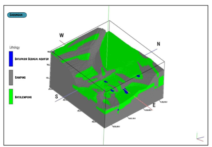
Limestone is one of the most important non-metallic mineral commodities widely used in the cement, steel, fertilizer, and construction industries. North Konawe Regency, particularly in Sawa District, has significant limestone potential; however, subsurface distribution information remains limited. This study aims to identify the distribution of limestone using the 2D resistivity geoelectrical method with a Wenner–Schlumberger configuration. Measurements were conducted along four survey lines, each 290 meters in length with 10-meter electrode spacing, enabling subsurface investigation down to approximately 57 meters. The acquired data were processed using Res2Dinv software to generate 2D resistivity cross-sections, which were further integrated into a 3D model to estimate resource potential. Interpretation results indicate three main subsurface zones: an aquifer layer with low resistivity (8–33 Ωm), claystone with medium resistivity (64–344 Ωm), and a compact limestone layer characterized by high resistivity (474–14,772 Ωm). The 3D model reveals an extensive and continuous limestone distribution, with an estimated volume of 11,845,136 m³ across an area of 207,790 m². These findings demonstrate that the resistivity geoelectrical method is highly effective for limestone exploration, while also providing accurate preliminary data to support sustainable mineral resource management and utilization planning in the study area.
References
Dahlin, T., & Zhou, B. (2004). A numerical comparison of 2D resistivity imaging with ten electrode arrays. Geophysical Prospecting, 52(5), pp. 379–398. https://doi.org/10.1111/j.1365-2478.2004.00423.x
Hasria, H., Dwiyanti, P., Azzaman, M., Okto, A., & Septiana, S. (2024). Pemanfaatan Batugamping pada Formasi Matano di Kecamatan Wiwirano Kabupaten Konawe Utara, Provinsi Sulawesi Tenggara. Jurnal Geosains dan Teknologi. 7(2), pp. 83–93. https://doi.org/10.14710/jgt.7.2.2024.83-93
Jahidin, J., Rubaiyn, A. & Andrian, A. 2025. Estimasi Cadangan Batugamping Berdasarkan Data Resisitivitas Pada Area PT Graha Batu Perdana Kabupaten Morowali. Jurnal Rekayasa Geofisika Indonesia, 7(1), pp. 57-65. https://doi.org/10.56099/jrgi.v7i01.46
Loke, M. H. (2004). Tutorial: 2-D and 3-D Electrical Imaging Surveys. Penang, Geotomo Software.
Loke, M. H., Chambers, J. E., Rucker, D. F., Kuras, O., & Wilkinson, P. B. (2013). Recent developments in the direct-current geoelectrical imaging method. Journal of Applied Geophysics. 95, pp. 135–156. https://doi.org/10.1016/j.jappgeo.2013.02.017
Martadiastuti, V., Pratiwi, B., & Ali, R. K. (2022). Estimasi Cadangan Batugamping sebagai Bahan Baku Utama Semen pada Kuari Batugamping, PT Semen Indonesia (Persero), Tbk., Kabupaten Rembang, Provinsi Jawa Tengah. Jurnal Geosains dan Teknologi. 5(1), pp. 53–60. https://doi.org/10.14710/jgt.5.1.2022.53-60
Octova, A., Hashim, M. H. M., Simatupang, T. S., Febriandika, H., Gusman, M. & Yulhendra, D. 2025. Integrated passive seismic and geoelectrical resistivity methods for cavity identification in limestone quarry. Journal of Applied Geophysics. 241, pp. 105836. https://doi.org/10.1016/j.jappgeo.2025.105836
Puspitasari, N. D., Massinai, M. F. I., Hasan, A., Rahayu, D., & Nurdin, N. H. (2019). Subsurface prediction using resistivity method (Case Study: Bira, South Sulawesi, Indonesia). Journal of Physics: Conference Series. 1341(8), pp. 082028. https://doi.org/10.1088/1742-6596/1341/8/082028
Rahmaniah, A., Wahyuni, A., Massinai, M. F. I., Mun’im, A., & Massinai, M. A. (2021). Resistivity Method for Characterising Subsurface Layers of Coastal Areas of South Sulawesi, Indonesia. Journal of Geoscience, Engineering, Environment, and Technology (JGEET). 6(4), pp. 217–225. https://doi.org/10.25299/jgeet.2021.6.4.6242
Reynolds, J. M. (2011). An Introduction to Applied and Environmental Geophysics (2nd ed.). Chichester, Wiley-Blackwell.
Rusmana, E., Sukido, Sukarna, D., Haryono, E., & Simandjuntak, T. O. (1993). Peta Geologi Lembar Lasusua–Kendari, Sulawesi, skala 1:250.000. Bandung, Pusat Penelitian dan Pengembangan Geologi.
Siregar, Y., Anjani, P., Pebrisa, G., & Deliana, A. (2023). Potensi Sumberdaya Batugamping sebagai Bahan Baku Semen di Kecamatan Junjung Sirih. JGE (Jurnal Geofisika Eksplorasi). 9(2), pp. 101–110. https://doi.org/10.23960/jge.v9i2.257
Surono 2013. Geologi Lengan Tenggara Sulawesi (2 ed.). Bandung, Badan Geologi.
Suryadi, A., Pratama, D. T., Kausarian, H. & Batara, B. 2023. Aplikasi Electical Resistivity Imaging (ERI) untuk investigasi Airtanah: Studi Kasus di Halaman Gedung Rektorat Universitas Islam Riau. OPHIOLITE : Jurnal Geologi Terapan, 5(2), pp. 70-77. https://doi.org/10.56099/ophi.v5i2.p70-77
Ward, S. H. (Ed.). (1990). Geotechnical and Environmental Geophysics. Volume 5, Investigations in Geophysics. Tulsa, Oklahoma, Society of Exploration Geophysicists.
Downloads
Published
How to Cite
Issue
Section
License
Copyright (c) 2025 Mochamad Mussoddaq, Hariono La Pili

This work is licensed under a Creative Commons Attribution-ShareAlike 4.0 International License.